PREFACE
Hello, today is 08/03/2026, and yes, in this text, I’ll be going over ANOTHER product from the tech giant Google. This is probably the 3rd time I did this in fact, the past 2 being about Google Search and YouTube. Google is pretty innovative and their products are amongst the most popular on the internet, so this does somewhat make sense. Although I’ll try to restrain myself from doing another Google product next time, trust.
Now that I hit writer’s block for the Preface section, we can officially begin the essay. This is probably the most content-heavy out all the tech essays I posted in the Chatting Area so far, so buckle up, we’re in for a long one.
AN ESSAY ABOUT GOOGLE MAPS
Fun fact: there are over 1,000,000,000 adults driving every day in the world, with probably a lot more people moving around without their own car. These people each have an idea in mind of where they want to go, such as back home or a foreign state for vacation purposes. Now, what specific software do you think they are using the most often while on the road? The answer? Google Maps.
As mentioned in the Google Search essay, Google was founded in the year 1998. In a few years, Google had already changed a lot. The 2 founders of Google, Larry Page and Sergey Brin, stepped down from the role of CEOs (to executives) in 2001. Google IPO’d in 2004, officially cementing its status as a tech giant. The corporation also began exploring and developing ventures outside of internet search engines. For example, they launched their email software: Gmail in 2004. Google Maps was going to become one of their new ventures.
Now Google Maps wasn’t actually started in Google’s offices in Silicon Valley. Rather, it was on another continent. An Australian startup called Where 2 Technologies that was founded by Stephen Ma, Lars and Jens Rasmussen, along with Noel Gordon in the year 2003. It was a very small startup, and all the founders were still struggling financially after the 2001 Dot-Com Bust*. Anyways, the startup developed a downloadable C++ mapping program “Expedition,” which essentially displayed the geographical spatial data of the planet Earth.
(*During the 1990s, the internet was mainstream and all the rage. There were thousands of Internet companies, like Amazon, out there in the market developing functioning (.com) websites. A bunch of finance bros were just throwing millions of USD in funding towards these corporations. Investors invested a lot on money in these corporations’ stocks as well. Success in the tech market was unfortunately unsustainable. In 2001, the stock market crashed, causing mass bankruptcy, layoffs, and unemployment in the tech sector. This became known as the 2001 Dot-Com bust, it took over 10 years for the market to fully recover)
If you haven’t guessed already, Google would acquire the tech startup in 2004 after the founders of Where 2 Technologies pitched their idea to Google. The amount Google paid for the acquisition is unknown. The tech giant then turned the downloadable C++ mapping program into a full-stack web application using a special web-development technique called AJAX. That specific web application would be released as Google Maps in 2005.
Perhaps the most notable feature that Google had implemented in Maps was pathfinding. Let’s say you want to visit your friend in his house a few miles away from yours; you would use Google Maps to show you a specific route/path with specific directions that will guide you to your friend’s house. Now, the question becomes, how does the software generate that specific path? To handle this, Google Maps implemented a special, powerful algorithm, known as Dijkstra’s algorithm, devised by one of the greatest Computer Scientists of all time, Edsger W. Dijkstra, in 1956.
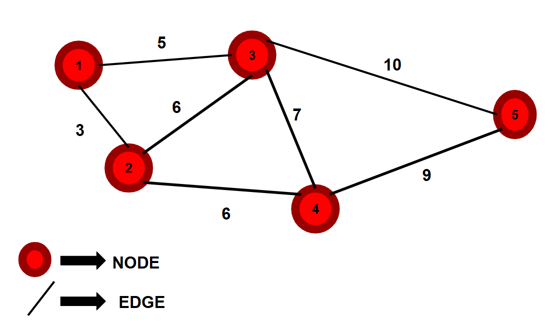
Dijkstra’s algorithm revolves around a type of data structure called a graph. Now, graphs are built around 2 main entities. One is nodes, which are the objects used to represent the graph’s data. The other entity is the edges; these are the lines that connect all the nodes with one another. Numbers can also be attached to the edge lines like labels; these numbers are called Weights. They aren’t required for a graph structure to function properly, but in the context of Dijkstra’s algorithm, they matter a lot.
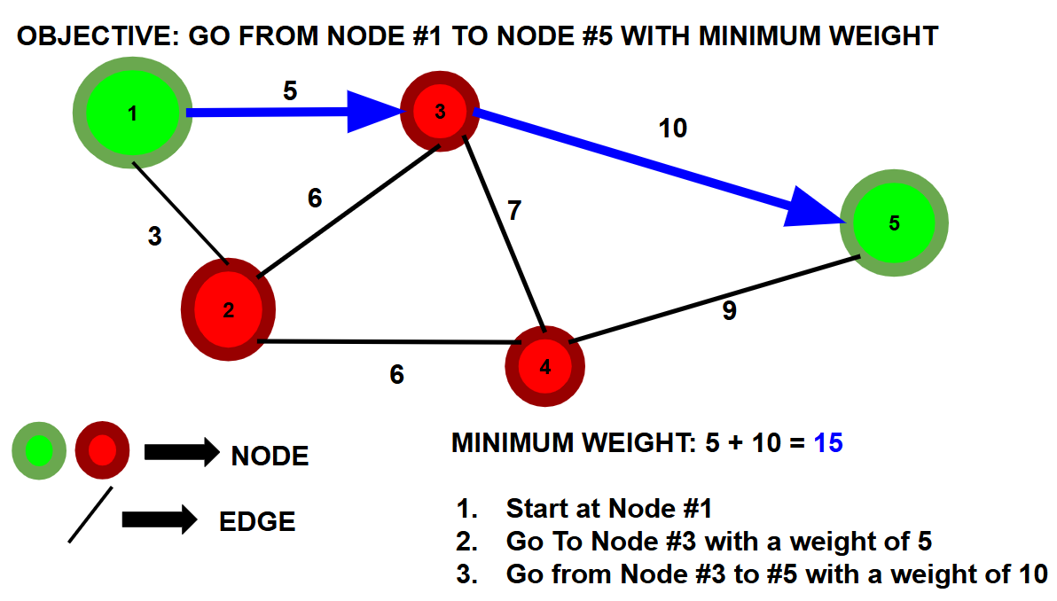
As far as what Dijkstra’s algorithm actually does in a graph? Simply put, Dijkstra’s algorithm will compute and return the shortest path between one node and any other node, AKA the path with the least amount of weight involved. Finding this involves a lot of path-testing and going towards multiple edges + directions. As one may expect, Dijkstra’s algorithm has a lot of applications to optimization problems.
In the case of Google Maps, any specific location (e.g., New York City) in the world can be represented as a graph’s node. The physical roads that connect specific locations (nodes) represent the graph’s edges. The distance, time, and other expense metrics between any 2 neighboring locations represent the weights of the graph. So the idea is that you start at a specific node, you set your destination to a different node, and Dijkstra’s algorithm will compute the path between you and the destination with the smallest amount of weight. That specific path will be what Google Maps recommends to you for directions.
Now, this world is massive; there are billions of landmarks and roads on this planet. If we only had Dijkstra’s algorithm constantly checking every last possible edge/road, out of thousands or millions or billions, all to find the least amount of weight to reach a specific destination, then things would be extremely slow.
Google realizes this optimization issue, so how did they handle this? They implemented an algorithm called A*. Now, instead of having algorithms spread out in every possible direction in the graph, it will have the algorithm prioritize the paths directly facing the destination. For example, if your school is located in the Northwestern direction away from your home, Google Maps will primarily focus on the paths that involve moving in the North or West direction one way or another. This cuts down a lot of work for Dijkstra and reduces a lot of latency. But what if I told you that Google can optimize even further?
For path-finding in Google Maps, not all paths/roads are made equal. Google Maps has a hierarchy for all types of roads. Famous highways are typically ranked the highest, and neighborhood streets could be interpreted to be on the lower end. The rankings for such roads are pretty dependent on how they handle traffic over long distances and their speeds when doing so. When calculating all the different pathways with A* and Dijkstra’s, Google Maps will mainly prioritize the roads with the highest ranks in the hierarchy, or just remove the lowest-ranked roads from the picture as much as possible. Such a concept is otherwise known as Contraction Hierarchies.
This is only scratching the surface. Google Maps utilizes a lot more algorithms than A* and Dijkstra’s algorithm (they are still used) with Contraction Hierarchies, but they remain as a fine baseline for how Google Maps’ pathfinding mechanics work. Now, as mentioned, the world is vast. But somehow Google Maps knows everything about what the world contains and what it looks like with LIVE updates. It knows the specific speed limits on each street + road; it has a 1:1 layout of your neighborhood and everybody else’s neighborhoods. Not even the most detailed physical maps can fit all this, so how does Google get all that geographic data?
To get the 1:1 layouts of the world and its structures, Google utilizes aircraft (e.g., planes) with special cameras (at a multitude of different angles) mounted onto them. The 2D images taken by the airborne machinery provide Google Maps with the data needed to generate some specific + accurate 3D physical landscapes of the world, which the user will be able to view when using Google Maps. Google also uses satellites in orbit for aerial photography, although photos will turn out a lot more zoomed out with less detail (although covers a lot more space).
It’s not like the 2D photo has to be taken several miles up in the sky either; Google also set up cars on the pavement, mounted with special cameras and GPS equipment. These are called Google Street View Cars. The cars would drive around on the roads with the sensors and camera surveying the structures and terrain the vehicle is driving around. This produces Google Maps’ 3D landscapes at ground level, potentially covering parts of the terrain that aerial photography missed (e.g., stuff in alleyways).
To get live, updating data, such as traffic accidents that only just happened, Google uses a technique called Crowdsourcing. In a nutshell, crowdsourcing is basically just getting data from a large group of users. Most often, Google Maps will continuously track the user’s location while they’re moving around, and the user’s movement (speed) data is sent to Google’s servers, allowing Google to get a good grasp on the current traffic and limits. Users can also manually send reports to Google about any live updates that they saw as well. Maps should be quickly updated after that.
But that’s enough Google Backend stuff; how about the frontend part of things, the user interface? Well, Google Maps has a very powerful feature where you can interact and move the world map along in various ways, such as zooming into a specific location like the Eiffel Tower, or constantly dragging your map until you make it to the land of Asia. But how do such interactive features work?
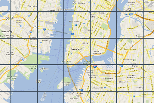
In Google Maps’ case, the entire world map is broken down into trillions of square tiles that have sizes of 256 x 256 pixels. When you first load Google Maps, you’ll merely see a bunch of tiles grouped together. When you drag the map to the left, the once-hidden tiles on the left would load into existence. When you zoomed in on any particular location, the tiles’ resolutions got higher with more detail. So, when you interacted with the map, the page no longer had to manually refresh to show you a new image of the world map, which was something that past mapping software like Yahoo Maps had to do. The user interaction feature in Google Maps is what makes the software a revolutionary one.
(…)
Before Google Maps released in 2005, if people wanted to go somewhere that involved going along roads/paths they weren’t familiar with, they would purchase a physical paper map to read and memorize, that or they learned to get reliant on highly-inconvenient mapping software. But, when Google Maps released, that all changed. People could now simply use a web application to get from place to place without needing to memorize anything or constantly waiting for a page to reload itself.
21 years have now passed since Google released Maps, and the web application only got even better and stronger by then. Today, the amount of people who use Google Maps exceeds 2,000,000,000 which is a very rough estimate of 25% of the world’s population. But, we can’t forget that Maps was not entirely Google’s idea, but of the very small Australian startup known as Where 2 Technologies. Their project went from very niche to one of the most dominant on the internet, something that only happens once a blue moon. But, perhaps, at the moment right now, somewhere in the world, there already exists a small tech startup whose product will shock the world, just waiting for recognition.
THE END